Hot, dry conditions continue in most areas of the province resulting in numerous wildfires. A provincial state of emergency has been declared. Albertans who require assistance can call 310-4455 for wildfire related information. https://www.alberta.ca/emergency.aspx
Hot and dry conditions will continue with no significant rain in the forecast. The average forecast across the Peace River Forest Area (PRFA) is a temperature of 24 degrees, a relative humidity of 25 per cent and light winds from the southwest of 15 km/h.
Wildland firefighters urge everyone to be extremely cautious when out in the Forest Protection Area. Check your winter burns, and comply with Fire Bans and OHV restrictions. At this time, fine fuels are critically dry and very receptive to fire.
There is an evacuation alert for the County of Clear Hills as GWF018 continues to be very active. This wildfire grew by approximately 500 ha yesterday north of the Peace River, and has crossed a fire guard. It is anticipated this wildfire will move toward Hwy 64, approximately along Range Road 84. For more information about this evacuation alert, visit https://clearhillscounty.ab.ca/
Wildfire Situation
Since January 1, there have been 43 wildfires in the Peace River Forest Area (PRFA) burning a total of 6,687.42 hectares (ha).
GWF018 is currently classified as Out of Control (OC). It is estimated to be 12831 ha in size. It is located approximately five kilometers east of Cleardale and 15 kilometers southwest of Worsley. This fire was very active today, growing by approximately 2,800 ha, and moving north. Wildland firefighters assisted by air support and heavy equipment are working to contain the wildfire. Hwy 64 is under a travel advisory. Clear Hills County has issued an evacuation alert for area residents.
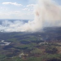
SWF068 is a provincial Wildfire of Note and is currently classified as Out of Control (OC). Peace River Forest Area has taken over control of this wildfire. It is estimated to be approximately 38,716 ha in size. Wildland firefighters are working to contain this fire after it was increasingly active today and broke through fire guards on the north and east flanks. It is currently being driven to the north by southerly wind.
PWF034 is currently classified as Being Held (BH). It is estimated to be 433ha in size. The wildfire has not grown since May 8, but increased visibility allowed for another assessment. Wildland firefighters and heavy equipment have completed a boundary around the fire, which is being monitored by firefighters.
PWF038 is s currently classified as Out of Control (OC) and located approximately 17 kilometers northeast of Three Creeks and 20 kilometers southwest of Simon Lakes. It is estimated to be approximately 6,207 ha in size and has crossed the East Haul Road. Significant progress has been made in establishing fire guards.
PWF025, PWF031, PWF028, PWF030 Are Under Control (UC).
PWF032, PWF027, PWF29 are Being Held (BH).
PWF026, PWF017, PWF012. PWF020, PWF008 are turned over.
Continue to stay informed by subscribing to Alberta Wildfire updates by entering your email. To view wildfires on a map, download the AB Wildfire App or visit the Wildfire Status page.
Caution is advised when travelling on area highways due to smoke conditions, especially in low lying areas. For road closures, visit 511 Alberta.
While we always appreciate people calling in to report wildfires, the large volume of calls we are currently receiving is diverting our resources away from other essential tasks. You can always visit firesmoke.ca to see where the smoke is coming from, and as always, please still call 310-FIRE if you see smoke or flame that looks new and potentially unreported, but assume that larger columns of smoke have already been detected. Thank you!
The Fire Danger in the Peace River Forest Area is EXTREME.
A Fire Ban and OHV Restriction is in effect for the entire Forest Protection Area of Alberta, including the Peace River Forest Area.
A fire ban and OHV restriction remains in effect. Firefighters urge everyone to continue using caution and to report wildfires immediately by calling 310-FIRE (3473).
Report wildfires immediately by calling 310-FIRE(3473).
Northern Sunrise County has lifted an evacuation alert for some areas within the municipality.
The mandatory evacuation notice has been lifted in Northern Sunrise County. Residents are now allowed to return to their homes. Please be prepared for the fact that you may not have power at your home. Although the evacuation notice has been lifted, if the situation changes, you may be asked to evacuate again with little notice.
There are widespread power outages in the County. ATCO crews are assessing the damages and assigning priorities. ATCO would like to caution residents to stay clear of any downed power lines, and/or ATCO crews working in the area. They will work to restore power as soon as possible.
Downed power lines can be extremely dangerous. Contacting an energized line can seriously injure or kill you. If you see a downed power line, please stay at least 10 meters away, call our Emergency outage line 1-800-668-5506 and keep everyone safe from the area.
For updated information on the power outages please refer to https://poweroutage.atco.com/map or download the ATCO app “My ATCO Electricity”.