Hot, dry conditions continue in most areas of the province resulting in numerous wildfires. A provincial state of emergency has been declared. Albertans who require assistance can call 310-4455 for wildfire related information. https://www.alberta.ca/emergency.aspx
The Fire Danger in the Peace River Forest Area is EXTREME.
A Fire Ban and OHV Restriction is in effect for the entire Forest Protection Area of Alberta, including the Peace River Forest Area.
At this time, fine fuels are critically dry and very receptive to fire.
Although cooler temperatures and some light rain fell in some parts of the Peace River Forest Area, the amount is not enough to improve conditions significantly or for the long term. Fine fire fuels such as dead grass require only a few hours of warm temperatures to dry out and become flammable.
A fire ban and OHV restriction remains in effect and firefighters urge everyone to continue using caution and to report wildfires immediately by calling 310-FIRE (3473).
Report wildfires immediately by calling 310-FIRE(3473).
Since January 1 there have been 40 wildfires in the Peace River Forest Area (PRFA), burning a total of 6696.33 hectares (ha).
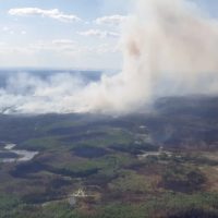
GWF018 is currently classified as Out of Control (OC). It is estimated to be 10,508 ha in size. It is located approximately five kilometres east of Cleardale and 22 kilometres southwest of Worsley. Dozer groups and wildland firefighters assisted by air tankers and helicopters are working to build fire breaks along the south and west flanks to utilize agricultural land and wetland areas to slow the wildfire’s growth. While the wildfire is generating considerable smoke in the Peace River valley, there is reduced fire activity on all flanks.
PWF034 is currently classified as Being Held (BH). It is estimated to be 433ha in size. The wildfire has not grown since May 8, but increased visibility allowed for another assessment. Wildland firefighters and heavy equipment have completed a boundary around the fire, which is being monitored by firefighters and helicopter support.
PWF038 is s currently classified as Out of Control (OC) and located approximately 17 kilometres northeast of Three Creeks and 20 kilometres southwest of Simon Lakes. It is estimated to be approximately 6,219 ha in size and has crossed the East Haul Road. Wildland firefighters, heavy equipment, helicopters and air tankers are being utilized for this wildfire, and fire retardant has been dropped to prevent continued growth on the fire’s west flank. Precipitation and cooler temperatures have allowed firefighters to gain significant progress in establishing fire guards.
SWF068 is a provincial Wildfire of Note and is currently classified as Out of Control (OC). Peace River Forest Area will be taking over control of this fire. It is estimated to be approximately 23,706 ha in size. Three helicopters, an equipment group and a unit crew are working to build a fireguard form the head of the fire down the north and south flanks. Municipal fire services are assisting with structural protection.
PWF025, PWF031, PWF028, PWF030 Are Under Control (UC).
PWF032, PWF027, PWF29 are Being Held (BH).
PWF026, PWF017, PWF012. PWF020, PWF008 are turned over.
None of the above wildfires are a threat to the Town of Peace River at this time. Continue to stay informed by subscribing to Alberta Wildfire updates by entering your email. To view wildfires on a map, download the AB Wildfire App or visit the Wildfire Status page.
Northern Sunrise County has lifted an evacuation alert for some areas within the municipality.
The mandatory evacuation notice has been lifted in Northern Sunrise County. Residents are now allowed to return to their homes. Please be prepared for the fact that you may not have power at your home. Although the evacuation notice has been lifted, if the situation changes, you may be asked to evacuate again with little notice.
The road closures are also being removed, except for a section of RR 190 that has some downed power lines.
The Reception Centre at the County Administration office will remain open today until 21:00 hours. The Emergency Coordination Center will continue to operate as required, also at the Administration office.
There are widespread power outages in the County. ATCO crews are assessing the damages and assigning priorities. ATCO would like to caution residents to stay clear of any downed power lines, and/or ATCO crews working in the area. They will work to restore power as soon as possible.
Downed power lines can be extremely dangerous. Contacting an energized line can seriously injure or kill you. If you see a downed power line, please stay at least 10 meters away, call our Emergency outage line 1-800-668-5506 and keep everyone safe from the area.
For updated information on the power outages please refer to https://poweroutage.atco.com/map or download the ATCO app “My ATCO Electricity”.
The State of Local Emergency continues at Northern Sunrise County.
Please follow updates on social media, the County website and Voyent Alert.
Clear Hills County has issued a Wildfire Alert and State of Local Emergency
PG80220 (Boundary Lake/Bear Canyon) BC Forestry will be sending in a team to assist with the Alberta portion of the wildfire.
GWF0018 (Peace Riverbank/Cleardale) the wildfire Fire Crews made progress on keeping the wildfire held today. Fire crews are actively preparing new guards on the east side of the fire. Fields to the north are being tilled to help to control any movement towards more populated areas.
Please refer to the map for location of the following updates:
If there is a threat of fire in your area:
listen for updates from authorities
be prepared to evacuate at a moment’s notice
have your vehicle stocked with supplies and ready to go
Fire crews are working diligently to keep you safe.
DO NOT attempt to fight these wildfires as they are dangerous if you see a
new fire please CALL 310-FIRE (3473).
For information on the status of the Village of Hines Creek please contact the Village office @ 780-494-3690