Hot, dry conditions continue in most areas of the province resulting in numerous wildfires. A provincial state of emergency has been declared. Albertans who require assistance can call 310-4455 for wildfire related information. https://www.alberta.ca/emergency.aspx
Hot, dry conditions will persist throughweekend leading to criticallydry fuels. Upper ridgebuildingover Albertathis weekend will bring temperatures as high as 32C and RH valuesas low as 15 per cent.
Wildland firefighters urge everyone to be extremely cautious when out in the Forest Protection Area. Check your winter burns, and comply with Fire Bans and OHV restrictions. At this time, fine fuels are critically dry and very receptive to fire.
Peavine Metis Settlement is under an evacuation order. SWF068 has been very active and flare ups continue to break through containment lines. Fire has damaged the power supply to the community and the settlement is currently without power. RCMP are assisting the Alberta Emergency Management Agency to advise residents of the evacuation. Residents can call the Settlement office at 780-523-2557 for more information.
There is an evacuation alert for the County of Clear Hills as GWF018 continues to be very active. This wildfire grew by approximately 2,500 ha yesterday and has reached Hwy 64. Highway 64 is closed in both directions from Range Road 74 to Range Road 91. For more information about this evacuation alert, visit https://clearhillscounty.ab.ca/
Wildfire Situation
Since January 1, there have been 44 wildfires in the Peace River Forest Area (PRFA) burning a total of 6,904.932 hectares (ha).
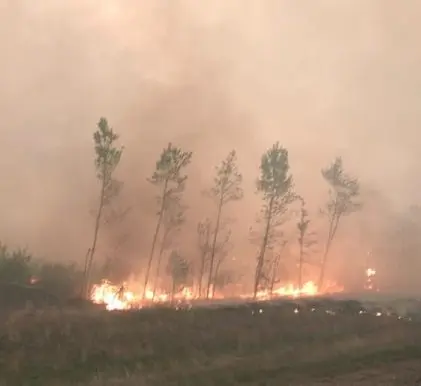
GWF018 is currently classified as Out of Control (OC). It is estimated to be 29,000 ha in size. It is located approximately five kilometers east of Cleardale and 13 kilometers southwest of Worsley. This wildfire was very active again today and is running parallel to Hwy. 64 on the north flank, and is expected to reach agricultural land to the east. It is burning parallel to the Peace River on the south. Wildland firefighters assisted by air support and heavy equipment are working to contain the wildfire. Hwy 64 is closed from Range Road 74 to Range Road 91. Clear Hills County has issued an evacuation alert for area residents. Wildland firefighters assisted municipal fire services yesterday to provide structural protection to five residences threatened by wildfire. All five residences were saved.
The Kimiwan Complex Wildfire PCX001 (SWF068 and PWF038) is a provincial Wildfire of Note and is currently classified as Out of Control (OC). It is estimated to be approximately 64,000 ha in size. Wildland firefighters are working to contain this fire after it was increasingly active again yesterday. Peavine Metis Settlement is under a mandatory evacuation notice due to the fire’s activity on the sourthwest flank. A forecasted low pressure system is expected to bring NW winds tomorrow or Tuesday. The wildfire’s north perimeter is approximately 38 kilometers south of Cadotte Lake and 39 kilometers south of Little Buffalo. It is currently being driven to the north by southerly wind.
WF034 is currently classified as Being Held (BH). It is estimated to be 433ha in size. The wildfire has not grown since May 8, but increased visibility allowed for another assessment. Wildland firefighters and heavy equipment have completed a boundary around the fire, which is being monitored by firefighters who continue to patrol this wildfire.
Continue to stay informed by subscribing to Alberta Wildfire updates by entering your email. To view wildfires on a map, download the AB Wildfire App or visit the Wildfire Status page.
Caution is advised when travelling on area highways due to smoke conditions, especially in low lying areas. For road closures, visit 511 Alberta.
The Fire Danger in the Peace River Forest Area is EXTREME.
A Fire Ban and OHV Restriction is in effect for the entire Forest Protection Area of Alberta, including the Peace River Forest Area.
A fire ban and OHV restriction remains in effect. Firefighters urge everyone to continue using caution and to report wildfires immediately by calling 310-FIRE (3473).
Report wildfires immediately by calling 310-FIRE(3473).
Clear Hills County has issued an Evacuation Alert and State of Local Emergency
An evacuation alert has been expanded as we move into the evening for the area of Highway 64 North on Range Road 74 to Township Road 854 West to Range Road 84 than back South to HWY 64.
All residents in the impacted area must prepare to evacuate on a one-hour notice.
Prepare to evacuate. gather pets, important documents and medication, and enough food, water and supplies for at least 72 hours.
An Alberta Emergency Alert will be issued if an evacuation order is required. Stay tuned to local media and follow the directions of the authorities.
The link below will take you to the Emergency Alert issued and contains an area map of the newly expanded area.
Northern Sunrise County has lifted an evacuation alert for some areas within the municipality.
The mandatory evacuation notice has been lifted in Northern Sunrise County. Residents are now allowed to return to their homes. Although the evacuation notice has been lifted, if the situation changes, you may be asked to evacuate again with little notice.
The road closures are in effect on South Harmon Valley Road TWP 822 at RR192.
There are widespread power outages in the County. ATCO crews are assessing the damages and assigning priorities. ATCO would like to caution residents to stay clear of any downed power lines, and/or ATCO crews working in the area. They will work to restore power as soon as possible.
Downed power lines can be extremely dangerous. Contacting an energized line can seriously injure or kill you. If you see a downed power line, please stay at least 10 meters away, call our Emergency outage line 1-800-668-5506 and keep everyone safe from the area.
For updated information on the power outages please refer to https://poweroutage.atco.com/map or download the ATCO app “My ATCO Electricity”.